Welcome to Tesla Motors Club
Discuss Tesla's Model S, Model 3, Model X, Model Y, Cybertruck, Roadster and More.
Register

Wiki Superchargers Visited

This site may earn commission on affiliate links.
**** NOTE: We have transitioned to a new platform ****
More Info: Supercharging.Life database

This is a friendly contest for Tesla owners to track the number of unique public Superchargers where they have charged

- "Supercharger count" is the number of unique public Superchargers where you have charged (just being there does not count), whether or not you were the person plugging in the vehicle (such as a Valet Parking garage or a Passenger) and whether or not it was your own personal vehicle (such as a rental, a loaner, or a friend's Tesla) as long as you were the one who drove >50% of the distance to reach the charger(s).
- The list of chargers in the supercharging.life database are the ones included in the game. If you think one should be added or removed from the list, let us know.
- Only chargers available to the public without special permission are included in the game.
- Chargers not connected to the grid are not counted.
- Doublet locations like the North/South Supercharger 'pairs' in CT, ME, NH, etc. count as individual locations.
- More than 1 charger at the same address, such as Lenox Square Mall (Atlanta, GA) or Montgomery Mall (Bethesda, MD) count as individual locations when they appear as a separate location on the Tesla Nav screen.
- Inactive competitors will be archived and removed from the leaderboard. Just post an update to be reactivated.

See Supercharging.Life database for info on how to post your own visits to the database (preferred), or post your locations with date visited to this thread and one of the admins will update your list for you. All visits must be posted to this thread - not just entered in supercharging.life. If you are the first in the game to visit a supercharger location, please post to the thread as soon as you can so others know it has been visited.
 
Last edited by a moderator:
Safe travels for your grand tour!

June will be interesting for your adventure out here. Be prepared for just about any type of weather: Cool with the dread June gloom along the coast and a wee bit inland. ("Late night and early morning low clouds giving way to partly sunny skies by afternoon. Highs 61-66. Overnight lows 52-55" is a common weather refrain.)

Expect scorching temperatures with not much cooling overnight in both the high and low deserts. The interior valleys (San Bernardino/Riverside; Central Valley including the foothills from the Grapevine to Redding; Napa Valley) will be hot but not as hot as the deserts. The Sierra will be generally very comfortable during the days but might get chilly overnight. The North Coast (Eureka/Crescent City and south) could get intermittent rain on many days with partly cloudy conditions otherwise. The north state (Yreka/Weed/Mt. Shasta City and Alturas) is generally quite nice with no rain and warmish days. The eastern side of the Sierra (Susanville south along 395 to Lone Pine) gets warmer the further south you go. The nights are very pleasant.

The winter closures across the Sierra (highway 120 through Yosemite/Tioga Road, plus route 4 (one lane for 20+miles) and route 108 will be open in addition to the more frequently traveled highways (88,50,80,20) that are open year 'round. If you choose to cross the Sierra on Tioga Road through Yosemite, you might need to make a reservation--the Park Service has their rules about admissions into the Park. And get your Senior Pass for free admission. I think the fee is now $35 for a seven-day pass.

In case you don't know, California is an open-range state. On non-limited access roads and highways, livestock have the right of way. While it is not common to see steer or sheep ambling along or across the road, or grazing outside the fence, it does happen. I've encountered animals scores of times in my 50+years of driving hither and yon.

You'll have lots to choose from for your SC hunting! Enjoy!
The sell a lot of sweatshirts to tourists in San Francisco in August. 😀
 
He has hunted in CA before, excepting the very north part.
Oh yes; I was well-aware of this. I did not look into the dates of his visits on his map. So, I tried to cover all bases in describing typical June weather in the larger geographic regions of this large and glorious state.

It can be curious to be along the coast and be in the midst of coolish, almost foggy weather. Then a turn inland to the east and within 5-10 miles it is 25 degrees warmer and sunny. This is especially true from Marin County north along SR 1 and again in Humboldt County (Eureka).


The sell a lot of sweatshirts to tourists in San Francisco in August. 😀
My point exactly.

Here is the latest skinny on Yosemite and reservations:


As of today for the entire month of June, reservations are required for entry on weekends and holidays. On the other days, entry is permitted without reservations. Of course, this is always subject to change.
 
Oh yes; I was well-aware of this. I did not look into the dates of his visits on his map. So, I tried to cover all bases in describing typical June weather in the larger geographic regions of this large and glorious state.

It can be curious to be along the coast and be in the midst of coolish, almost foggy weather. Then a turn inland to the east and within 5-10 miles it is 25 degrees warmer and sunny. This is especially true from Marin County north along SR 1 and again in Humboldt County (Eureka).
I still wear a fleece jacket I bought from the Monterey Aquarium on one of our visits, as we didn't have cold weather gear, and it was bloody cold.

July 2014
1714249180670.png

Here is the latest skinny on Yosemite and reservations:


As of today for the entire month of June, reservations are required for entry on weekends and holidays. On the other days, entry is permitted without reservations. Of course, this is always subject to change.
I've bookmarked this site and will try to go through during the week. I don't know my plans well enough to reserve ahead of time. I've been to Yosemiti several times, so it isn't a must-do on this trip.
 
For those collecting in Colorado, please be aware that US 50 is closed at Blue Mesa Reservoir for an emergency bridge repair. This is expected to be a long term closure. So, no direct travel between Poncha Springs Supercharger Station and Montrose Supercharger Station (Monarch Pass/ Gunnison) for some time to come. I-70 is the best alternate route for travel between the Front Range and the Montrose area.

Matters for me because I was going to take that route on our 7000 mile road trip to Canada and the eastern US, beginning May 4. I-70 will have to do.

As always, Colorado road conditions can checked at cotrip.org. Snowing here today, but too warm for it to stick.
 
First time I've seen a non-Tesla at a SC. I assume many of you have seen this? This at Fredonia NY that probably has a 5% occupancy rate -- so assume Tesla only shares for under-used SCs? sorry a bit off topic - but you are the experts.

Interesting. I also saw two non-Teslas charging today in WA and OR - the first I have seen in the US. There was a Rivian towing a U-Haul trailer charging at Kelso, WA and a Mach-E charging at Detroit Lake, OR
 
Arches/Monument Valley Trip - Day 1

We are on what should be a 9 day trip to visit Arches National Park in UT and Monument Valley in AZ, taking in new Superchargers on the way in UT and coming back to Seattle via CO & MT.

Check-ins for 2024-04-27

- Tacoma - S Hosmer St, WA (#2373) (First to check-in)
- Sisters, OR (#2374)
- Klamath Falls - Crater Lake Pkwy, OR (#2375) (First to check-in)

Image 4-27-24 at 9.37 PM.jpeg
Image 4-27-24 at 9.38 PM.jpeg
Image 4-27-24 at 9.38 PM (1).jpeg


Here's a photo of a Rivian charging at Kelso, WA.

Screenshot_20221109-103017.jpeg
 
For those collecting in Colorado, please be aware that US 50 is closed at Blue Mesa Reservoir for an emergency bridge repair. This is expected to be a long term closure. So, no direct travel between Poncha Springs Supercharger Station and Montrose Supercharger Station (Monarch Pass/ Gunnison) for some time to come. I-70 is the best alternate route for travel between the Front Range and the Montrose area.

Matters for me because I was going to take that route on our 7000 mile road trip to Canada and the eastern US, beginning May 4. I-70 will have to do.

As always, Colorado road conditions can checked at cotrip.org. Snowing here today, but too warm for it to stick.
I-40 is also closed in NM near the AZ border due to a fuel train derailment. Must be a huge mess!
 
Check-ins for 2024-04-27
- Lumberton - W 5th St, NC (#2938)
- New Bern - Dr MLK Jr Blvd, NC (#2939)
- Nags Head, NC (#2940)
- Norfolk - 1146 N Military Hwy, VA (#2941)
- Suffolk, VA (#2942)
- Franklin, VA (#2943)
- Stony Creek, VA (#2944)
- Hopewell, VA (#2945)

Check-ins for 2024-04-28
- Woodbridge - Daniel Stuart Sq, VA (#2946)
- Washington - Idaho Ave, DC (#2947)

Long night of driving, but I made it through DC in the wee hours with no traffic so happy about that. Now let's see if I can make it through NYC in the wee hours tomorrow, because driving around there on a Monday would totally suck!
 
For those collecting in Colorado, please be aware that US 50 is closed at Blue Mesa Reservoir for an emergency bridge repair. This is expected to be a long term closure. So, no direct travel between Poncha Springs Supercharger Station and Montrose Supercharger Station (Monarch Pass/ Gunnison) for some time to come. I-70 is the best alternate route for travel between the Front Range and the Montrose area.

Matters for me because I was going to take that route on our 7000 mile road trip to Canada and the eastern US, beginning May 4. I-70 will have to do.

As always, Colorado road conditions can checked at cotrip.org. Snowing here today, but too warm for it to stick.

Monarch Pass is the coolest route over the mountains, but it takes forever.

I've only done it in an ICE car so far, but I'll be visiting in-laws in Utah in July and would have been tempted to take this route, so thanks for the warning.
 
We visited my wife's grandmother again yesterday.

Check-ins for 2024-04-27
- Gainesville, GA (#557)
- Gaffney, SC (#558)

I charged up to 100% right before we left in the morning, and we pulled into the new-to-me Gainesville supercharger with about 16%. I really hate driving that far in one stretch without getting out of the car to stretch my legs, but it's nice to have the option not to stop.

I was thinking about it, and when we got our Model Y, the only Supercharger open yet between Charlotte and the north Atlanta suburbs was the original Greenville, SC, site. However, by the time we made the trip to Gainesville again, the Fair Play, SC, site had recently opened. Fast-forward two years, and counting very short diversions of a couple of miles each, there are nine (9) superchargers between Charlotte and my wife's grandmother in north Georgia.

  1. Gasontia, NC
  2. Gaffney, SC
  3. Spartanburg, SC
  4. Greenville - Haywood Rd., SC
  5. Greenville, SC
  6. Piedmont, SC
  7. Fair Play, SC
  8. Commerce, GA
  9. Gainesville, GA
It really highlights how well Tesla has improved the charging options for interstate driving.

We stopped in downtown Greenville, SC, to break up the drive. Had heard good things about their downtown river walk, but first time experiencing it. Really beautiful little downtown, and too much tempting good food.

IMG_2053.jpeg
 
Monarch Pass is the coolest route over the mountains, but it takes forever.

I've only done it in an ICE car so far, but I'll be visiting in-laws in Utah in July and would have been tempted to take this route, so thanks for the warning.
Monarch Pass is a lot more fun to drive than I-70. But if you want a really scenic and fun drive, try US 550 over Red Mountain Pass from Durango to Ouray. The section from Silverton to Ouray is known as the "Million Dollar Highway."

Of course I am biased because little Ouray County, population 5000, has been my home for several decades!

US 50 may be open again by July. Check before you head to Utah.
Keep the road suggestions coming across the West. I expect these wonderful roads will comprise a big part of my route planning from late May through late July.
 
Oh, dang, I was just there, but decided to take the route down from Mountain Village (Telluride) thru Cortez to Durango as it didn't require any backtracking. If I had only known the other road would be prettier. Looks like it runs along the peak of the mountains too, very much like the Top of the World route northeast of LA near Lake Arrowhead
 
Last edited:
  • Like
Reactions: NKYTA
Keep the road suggestions coming across the West. I expect these wonderful roads will comprise a big part of my route planning from late May through late July.
Flyer,

I can offer up California:

(1) Download the CalTrans QuickMap to your phone. This is updated frequently throughout the day. You can select from a menu what it is you wish to appear on the map display; inter alia: Displays on the message boards; road closures/construction/delays/incidents; traffic cameras; winter (haha!) advisories like chain controls and where the plows are.

(2) You can access online specific highway information at the following website linked below:


You can enter any number of highway numbers by separating them with a comma. As indicated above, State Signed Route 1 has an emergency closure south of Monterey and one lane available south of Lompoc due to a washout. There is no timetable for reopening at present. In addition, Route 41 south of its junction with Route 198 near Lemoore in the Central Valley is closed for a bridge replacement, and will likely be closed into August. If your planning is to go from Highway 99 near Fresno or Visalia to the Central Coast at Paso Robles or San Luis Obispo, you will need to navigate around this closure through Avenal.
 
I-40 is also closed in NM near the AZ border due to a fuel train derailment. Must be a huge mess!
My nephew is driving TN to CA along I-40, in a gas car, he is affected by the closure.

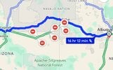
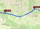
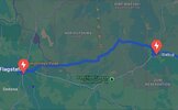
I checked the route from ABQ to SF in Google Maps, ABRP and the Tesla App trip planner.

Yesterday 4/27 Google maps showed the re-route, Telsa App trip planner did not, ABRP did not.

Today, 4/28 as of 11:00am PDT, just checked NMRoads.com and az511.gov, seems the closure has narrowed a bit.
Google maps shows the re-route, Tesla App trip planner shows the re-route, ABRP still tries to route along normal route I-40.

Yesterday, If I was in my older M3 with 100% rated range of 264 mi. (yup!!!). I would have routed via I-25/I-10/LA instead Google maps detour.

I have run across this before last year on I-80 somewhere in IA there was roadwork and Tesla just routed me through it and Google Maps came up with a not EV friendly route.

Do not have CCS, but as a fall back not many/zero charging options in the above re-route. With CCS can mb short circuit to Winslow, charge at EA. Newer cars with full range can probably make the trip fine, so says the planner.


Still a bit of planning required on these routes and detours can monkey things up !!!

Google Maps
IMG_4824.jpeg

ABRP
IMG_4823.jpeg

Tesla App trip planner
IMG_4822.jpeg
 
  • Informative
  • Like
Reactions: PLUS EV and NKYTA