Day 1
Once again, I miscalculated how much vacation I carried over from last year, and have to use a week before the end of March or lose it. So, I used airline miles to buy a ticket to LAX and scheduled a rental Model Y LR. (I wanted a Model 3 LR, but there were none available to reserve for the dates I needed.) I'll be visiting family and friends in LA, SLO, and SF throughout the week. Plan to take US-101 north, and if the weather cooperates, I'll cross the mountains and take US-395 South.
My wife and I had a good experience renting a Tesla from Hertz in Miami back in Fall 2022, so I didn't anticipate any trouble when I arrived Friday evening. However, it was a totally different experience this time. I didn't see my name on there reservations board, so I couldn't just go straight to my car--I had to go up to the desk. The first person I talked to said they didn't have a Model Y for me, but I could pick any gas car in the "President's Circle".
I guess he thought I would be happy, and he seemed surprised when I told him I would wait while they found me a Tesla. While I waited, I wandered out to that President's Circle, where there were 2 Model Y LR cars sitting. Back into the office, where I asked if I could have one of those. After a few minutes of them "checking on it", they gave me one of those Model Ys. I wasn't able to set up my phone as a key, and the two Hertz employees I asked about it said they had never heard of such a thing.
I was embarrassingly snippy after at least two Hertz employees said, "You know, we're getting rid of our Teslas." My edited response was, "Well, I guess I won't be able to rent from Hertz again, because I hate driving gas cars."
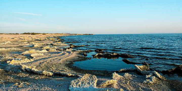
The trip has gotten better since then. My brother-in-law and I took a day trip on Saturday to the Salton Sea. I had heard about it and seen pictures for years now, but the act of driving around it was awesome. It is surreal to see this huge lake in the desert. If you have a day to spend in Southern California, you should see it. We mainly stopped around the south end. Check out the Sonny Bono Salton Sea National Wildlife Refuge. There is a new ChargePoint Level 2 unit with 2 plugs in the Visitor Center parking lot, and the volunteers in the office will tell you all you could ever want to know about the history and ecology of the area. We hiked up a couple of volcanoes that erupted as recently as the first millennium CE.
For those who are wondering about charging, the superchargers and Level 2 chargers are so thick on the ground in Southern California, I'm not even really planning charging on this trip. If you go to the Salton Sea with a newer Tesla, you are able to do it easily by charging up on the way out, and then again on the way back, in the Palm Springs area
.
Old tourism area on the northwest side of the Salton Sea

Sonny Bono Salton Sea National Wildlife Refuge Visitors Center

Rock Hill, the second highest volcano on the south end of the Salton Sea

View of the Salton Sea from the top of Rock Hill

View of Obsidian Butte, the largest volcano in the chain, from the top of Rock Hill

Looking northwest across Salton Sea toward the Santa Rosa Mountains

Mud pots near one of the geothermal plants around the Salton Sea

Pumice and obsidian on Obsidian Butte

Folded rock on Obsidian Butte

Sunset over the Salton Sea

Once again, I miscalculated how much vacation I carried over from last year, and have to use a week before the end of March or lose it. So, I used airline miles to buy a ticket to LAX and scheduled a rental Model Y LR. (I wanted a Model 3 LR, but there were none available to reserve for the dates I needed.) I'll be visiting family and friends in LA, SLO, and SF throughout the week. Plan to take US-101 north, and if the weather cooperates, I'll cross the mountains and take US-395 South.
My wife and I had a good experience renting a Tesla from Hertz in Miami back in Fall 2022, so I didn't anticipate any trouble when I arrived Friday evening. However, it was a totally different experience this time. I didn't see my name on there reservations board, so I couldn't just go straight to my car--I had to go up to the desk. The first person I talked to said they didn't have a Model Y for me, but I could pick any gas car in the "President's Circle".
I guess he thought I would be happy, and he seemed surprised when I told him I would wait while they found me a Tesla. While I waited, I wandered out to that President's Circle, where there were 2 Model Y LR cars sitting. Back into the office, where I asked if I could have one of those. After a few minutes of them "checking on it", they gave me one of those Model Ys. I wasn't able to set up my phone as a key, and the two Hertz employees I asked about it said they had never heard of such a thing.
I was embarrassingly snippy after at least two Hertz employees said, "You know, we're getting rid of our Teslas." My edited response was, "Well, I guess I won't be able to rent from Hertz again, because I hate driving gas cars."
The trip has gotten better since then. My brother-in-law and I took a day trip on Saturday to the Salton Sea. I had heard about it and seen pictures for years now, but the act of driving around it was awesome. It is surreal to see this huge lake in the desert. If you have a day to spend in Southern California, you should see it. We mainly stopped around the south end. Check out the Sonny Bono Salton Sea National Wildlife Refuge. There is a new ChargePoint Level 2 unit with 2 plugs in the Visitor Center parking lot, and the volunteers in the office will tell you all you could ever want to know about the history and ecology of the area. We hiked up a couple of volcanoes that erupted as recently as the first millennium CE.
For those who are wondering about charging, the superchargers and Level 2 chargers are so thick on the ground in Southern California, I'm not even really planning charging on this trip. If you go to the Salton Sea with a newer Tesla, you are able to do it easily by charging up on the way out, and then again on the way back, in the Palm Springs area
.
Old tourism area on the northwest side of the Salton Sea
Sonny Bono Salton Sea National Wildlife Refuge Visitors Center
Rock Hill, the second highest volcano on the south end of the Salton Sea
View of the Salton Sea from the top of Rock Hill
View of Obsidian Butte, the largest volcano in the chain, from the top of Rock Hill
Looking northwest across Salton Sea toward the Santa Rosa Mountains
Mud pots near one of the geothermal plants around the Salton Sea
Pumice and obsidian on Obsidian Butte
Folded rock on Obsidian Butte
Sunset over the Salton Sea