Welcome to Tesla Motors Club
Discuss Tesla's Model S, Model 3, Model X, Model Y, Cybertruck, Roadster and More.
Register

Tesla Navigation vs. Google navigation routing

This site may earn commission on affiliate links.

SabrToothSqrl

Active Member
Dec 5, 2014
4,579
4,154
PA
I'm trying to get some tesla navigation vs. Google Maps navigation routes.

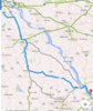
Port deposit, MD to Lewisberry, PA.

The tesla route is not only WAY out of the way, but would have left me with zero power before my destination.
I'm a little concerned for my road trip plans.

(Sorry for any previous confusion, I posted some 1/2 finished post and didn't get to edit it).

As you can see the Google route is the way I would, and do drive this route.

Is anyone else having issue with the routing, and why doesn't Tesla just use Google to route?

thanks.
I found this battery killing route feature while traveling from the Newark, DE super charger home.
I knew of the better route because I've launched at Port Deposit.
 

Attachments

  • image.jpg
    image.jpg
    1.7 MB · Views: 956
  • image.jpg
    image.jpg
    416.8 KB · Views: 712
Last edited:
I was just about to post myself. I drove from Naples to Sarasota to St. Petersburg, and to say the routes it chose were bizarre, it to give Tesla navigation more credit than it deserves.

When leaving Naples, it didn't seem to know I-75 existed. It even labelled it another county road number for about 10 miles when driving on it. Also, it wanted to send me on private roads for about 20 miles instead of the obvious route on the interstate.

When leaving Sarasota, it wanted to take me on local roads with unlimited stop lights instead of routing me to I-75. Basically it plotted out 16 miles of local roads instead of the interstate. When I got tired of that nonsensical routing, it repeated requested that I do a U-turn and turn around. Probably about 20 times on different intersections. When I got within about 1 mile of I-75, it finally gave up and said I could take I-75.

When the car came within about 8 miles of home, it was routing me past my house for about a 5 mile detour out of my way.

Now I can't find any way to have the car choose the fastest route instead of the shortest one like my Lexus can, and there is no explanation for the other bizarre behavior of the Nav system.

Am I missing something, or is it really this bad?
 
Ain't this the truth. I actually noticed this the other day when I had a much simpler way to travel from within a town out to the main road. The GPS wanted me to double back through the town, get on the highway, go one exit, then come out on the main road more North than I would have had I just followed main st out to the main road.

Well, I got to the main road and the GPS was telling me to turn RIGHT on the main road, go north back to the highway, go one exit, loop around, then get right back off on said main road and come back down.

Naturally, I simply made a left at the light. GPS removed 4 miles and 10 minutes from travel time :rolleyes:
 
In the 4-corners area, a systemic problem for the Tesla Nav is that it does not want to use Indian routes - Wikipedia.

Driving from the Farmington Supercharger to the Gallup Supercharger, Tesla Supercharger to Tesla Supercharger - Google Maps, Google Maps is happy to choose Indian Route 5, but the onboard nav wants to go through Shiprock, adding distance, time, and energy use. The same thing happens from Pagosa to Farmington. Once the car is several miles down the Indian Route, it will continue the nav on the Indian Route, but it will not do initial routing over an Indian Route.

From Cordes Junction, AZ to Gila Bend, AZ, Google Maps takes a shorter route than the onboard nav. 125 vs 131 miles — Tesla Cordes Lakes Superchager to Tesla Gila Bend Supercharger - Google Maps vs Tesla Cordes Lakes Superchager to Tesla Gila Bend Supercharger - Google Maps. In this case it seems to be a bias for the onboard nav to stay on Interstates.

BTW, in Google Maps, if you use the construct, "Tesla Supercharger, City, State," all of the open Tesla Superchargers are the data base with exact location in parking lots.
 
While I haven't had these sorts of issues with the Nav system, perhaps you should send these problems in as bug reports to Tesla. Presumably, Tesla is tinkering with the Nav system regularly and this sort of feedback might be helpful.
 
Could be that Musk's latest tweet is about a major upgrade to the navigation software.

Tesla's been aware the built-in navigation and media playback software are relatively basic, compared to current (and considerably older) cars - and while there's been some improvement since the first Model S was built, the system is still relatively limited - and if new functionality is added, it's more likely to be related to improving charge and range management than adding basic features such as providing several routing options (fastest, shortest, ...), waypoints, or traffic congestion warnings - features I had on my Lexus 8 years ago.

Though I miss those features - if Tesla can improve the charge and range management in the navigation software, that can be a considerably improvement - and something that could be critical if they want to sell 500K cars per year...
 
I too have noticed that "regular" Google maps nav planning that I might do on my computer at home differs than what the car will plot when I jump in to it and aim for the same destination. I also have a couple of funky routes form the car nav, one of which insists on routing me right through a parking lot when I really want to continue straight and make a left turn at the next intersection. Google maps on my computer also has a new bypass that the in-car nav doesn't

I wonder how much of this may have to with the interaction with the in-car Navigon system. We know the car can continue navigating even without internet connectivity to Google using the on-board Navigon database. I wonder if the route is calculated by Navigaon, and just displayed by Google maps, or vice-versa?
 
This is an email I sent to Tesla a week ago. Haven't heard a reply yet:

Attached are two pictures I took today, a few minutes apart. The first picture was taken at a stop light. The nav wanted me to go straight and take a long route around a mountain to get to my destination. I took the second picture a minute later, after I had turned left instead of going straight and the nav recalculated.

As you can see, the second route was shorter by 33 miles, and took 18 minutes less time.

Why did the nav give me a longer route to begin with? It looks like a routing software bug.

Please let me know as this sort of thing (non-optimal routes) happens frequently with me.

IMG_2072-2.jpg


IMG_2073-2.jpg
 
In the 4-corners area, a systemic problem for the Tesla Nav is that it does not want to use Indian routes - Wikipedia.

Driving from the Farmington Supercharger to the Gallup Supercharger, Tesla Supercharger to Tesla Supercharger - Google Maps, Google Maps is happy to choose Indian Route 5, but the onboard nav wants to go through Shiprock, adding distance, time, and energy use. The same thing happens from Pagosa to Farmington. Once the car is several miles down the Indian Route, it will continue the nav on the Indian Route, but it will not do initial routing over an Indian Route.

OTOH, if you've got the SOC, diverting to Ship Rock (the volcanic neck, not the town) is eminently worth doing. And once you've done that, arriving in Farmington from the west means you can (and should) bypass the snarled traffic in town by taking Piñon Hills Blvd around the north side.
 
Just drove from NYC to South Beach (after buying the car as you would imagine a little range anxiety) and it tried to take me off 95 via side roads at least three times during the trip and on a completely different highway with no supercharging once. Thank god the drive is a no brainier.