We've had our S85 for about a month now, and finally had a chance this past weekend for our first getaway up to Big Bear, elevation 6,800 feet. It's only 130 miles, but since there's a big elevation gain, I had the teensiest bit of range anxiety, and was tracking everything pretty closely. I wanted to post it here, since I bet there are plenty of other folks in Southern California who are going to be taking their Model S's up to Big Bear soon, and hopefully this will be helpful.
I should probably mention at this point that I've been dying to drive up these twisty-turny mountain roads in our S ("Weeeeeee!!!!"), so I had no expectations of achieving getting the "EPA" estimates...
We left our house with 259 rated miles (I did a near-max-range charge, just to be safe). We headed through downtown LA, and stopped in West Covina at Ikea (We had a few returns, it's just off the freeway, and hey, they have Blink chargers in their garage!). We had gone 38 miles so far and when we pulled in we had 215 miles left. We had lunch nearby, and then hit the road again after 90 minutes of charging, with 240 rated miles on the display.
We then continued East on the 10 freeway, and I had the cruise control set around 75mph most of the way. We got off the freeway in Redlands - elevation 1,440' - and had 187 miles of range left.
The next leg was the big climb, up to Onyx Summit, elevation 8,443'. (We like to take Hwy 38 instead of 330, since it's an easier drive and has less traffic. The only downside is that it's about 15 miles further, and you have to go up over Onyx Summit and then back down to Big Bear. Amusingly, the Tesla GPS really, really wanted us to turn around and go back to Hwy 330 -- I'm pretty sure the directions take elevation/energy usage into account, since it took a loooong time for it to give up and change to sending us up over the summit.)
From Redlands (1,440') we drove 37.5 miles to Onyx Summit (8,443'), almost exactly 7,000' feet up. We started with 187 rated miles, and crested the summit with 96 miles of range left.
So we got to the top of the mountain having reduced our range by 91 miles.
I've read on the forums that we can expect to "lose" about 7 miles of range for every 1,000' gain in elevation. Doing the math, we should have reduced our range by 86.5 miles (37.5 driven miles, plus 49 "miles" for elevation (7 miles * 7K feet)). Considering I was driving in "sport" mode (ahem), the 7 miles/1,000' estimate is impressively accurate.
We then coasted back down the 12 miles into Big Bear, pulling into our destination having gained a few miles from the regen.
On the return trip, I had no range anxiety, of course (it's all downhill from here!) - but I wanted to figure out how accurate the estimate of gaining 4 miles per 1,000' of elevation drop actually is.
We left Big Bear with 227 miles of rated range, and climbed back up to Onyx Summit. At the top, we had 203 miles of range. We then continued down the hill into Redlands, enjoying lots of regen (I don't think I had to touch the brake pedal even once!). Back in Redlands, we had climbed up to 209 miles.
So that's 37.5 driven miles, plus 28 "miles" for elevation (4 miles * 7K feet). If we're supposed to gain 4 miles for every 1,000' in elevation drop, we actually should have gotten down the hill with about 193.5 miles of range remaining. (203 rated range - 37.5 driven miles + 28 range regenerated = 193.5). In actuality, we were up 6 miles from when we started, so we actually regenerated 43.5 miles (203 rated range - 37.5 driven miles + 43.5 range regenerated = 209).
I'm guessing we did better on the regen (gaining 6.2 miles / 1,000' of elevation drop) because the bottom half of Hwy 38 is fairly steep and has long straightaways where we were consistently regenerating around 15 to 30 kW and were still moving about 60 MPH.
Now that I have some real numbers, I also wanted to figure out if we'd be able to do the drive again without the max-range charge, and without the stop to recharge along the way. Our total trip from home to Big Bear was 130 miles, and "used" a total of 189 rated miles... So if we left home with 243 rated miles and didn't stop to recharge along the way, I'd expect us to get to Big Bear with about 54 miles of range left.
(To clarify: Start with 259, go down to 215 at Ikea, recharge back to 240, then down to 95 at destination. 259-215=44, and 240-95=145. So 44+145=189 total rated miles used, and 243-189 = 54.)
Of course, if I didn't do 75 MPH on the freeway, and didn't take some of the turns up the mountain like a bat out of hell, we'd have even more range remaining when we arrived.")
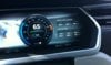
(In the pic below, the Trip A distance is from the base of the hill to Onyx Summit. We averaged 679 Wh/mile to get up the hill....)
I should probably mention at this point that I've been dying to drive up these twisty-turny mountain roads in our S ("Weeeeeee!!!!"), so I had no expectations of achieving getting the "EPA" estimates...
We left our house with 259 rated miles (I did a near-max-range charge, just to be safe). We headed through downtown LA, and stopped in West Covina at Ikea (We had a few returns, it's just off the freeway, and hey, they have Blink chargers in their garage!). We had gone 38 miles so far and when we pulled in we had 215 miles left. We had lunch nearby, and then hit the road again after 90 minutes of charging, with 240 rated miles on the display.
We then continued East on the 10 freeway, and I had the cruise control set around 75mph most of the way. We got off the freeway in Redlands - elevation 1,440' - and had 187 miles of range left.
The next leg was the big climb, up to Onyx Summit, elevation 8,443'. (We like to take Hwy 38 instead of 330, since it's an easier drive and has less traffic. The only downside is that it's about 15 miles further, and you have to go up over Onyx Summit and then back down to Big Bear. Amusingly, the Tesla GPS really, really wanted us to turn around and go back to Hwy 330 -- I'm pretty sure the directions take elevation/energy usage into account, since it took a loooong time for it to give up and change to sending us up over the summit.)
From Redlands (1,440') we drove 37.5 miles to Onyx Summit (8,443'), almost exactly 7,000' feet up. We started with 187 rated miles, and crested the summit with 96 miles of range left.
So we got to the top of the mountain having reduced our range by 91 miles.
I've read on the forums that we can expect to "lose" about 7 miles of range for every 1,000' gain in elevation. Doing the math, we should have reduced our range by 86.5 miles (37.5 driven miles, plus 49 "miles" for elevation (7 miles * 7K feet)). Considering I was driving in "sport" mode (ahem), the 7 miles/1,000' estimate is impressively accurate.
We then coasted back down the 12 miles into Big Bear, pulling into our destination having gained a few miles from the regen.
On the return trip, I had no range anxiety, of course (it's all downhill from here!) - but I wanted to figure out how accurate the estimate of gaining 4 miles per 1,000' of elevation drop actually is.
We left Big Bear with 227 miles of rated range, and climbed back up to Onyx Summit. At the top, we had 203 miles of range. We then continued down the hill into Redlands, enjoying lots of regen (I don't think I had to touch the brake pedal even once!). Back in Redlands, we had climbed up to 209 miles.
So that's 37.5 driven miles, plus 28 "miles" for elevation (4 miles * 7K feet). If we're supposed to gain 4 miles for every 1,000' in elevation drop, we actually should have gotten down the hill with about 193.5 miles of range remaining. (203 rated range - 37.5 driven miles + 28 range regenerated = 193.5). In actuality, we were up 6 miles from when we started, so we actually regenerated 43.5 miles (203 rated range - 37.5 driven miles + 43.5 range regenerated = 209).
I'm guessing we did better on the regen (gaining 6.2 miles / 1,000' of elevation drop) because the bottom half of Hwy 38 is fairly steep and has long straightaways where we were consistently regenerating around 15 to 30 kW and were still moving about 60 MPH.
Now that I have some real numbers, I also wanted to figure out if we'd be able to do the drive again without the max-range charge, and without the stop to recharge along the way. Our total trip from home to Big Bear was 130 miles, and "used" a total of 189 rated miles... So if we left home with 243 rated miles and didn't stop to recharge along the way, I'd expect us to get to Big Bear with about 54 miles of range left.
(To clarify: Start with 259, go down to 215 at Ikea, recharge back to 240, then down to 95 at destination. 259-215=44, and 240-95=145. So 44+145=189 total rated miles used, and 243-189 = 54.)
Of course, if I didn't do 75 MPH on the freeway, and didn't take some of the turns up the mountain like a bat out of hell, we'd have even more range remaining when we arrived.
(In the pic below, the Trip A distance is from the base of the hill to Onyx Summit. We averaged 679 Wh/mile to get up the hill....)